Route Planning for Safety: Water Sources, Elevation, and Escape Routes
Safe route planning requires systematically mapping water sources every day’s travel apart, as you’ll survive only 3-4 days without water. Scout streams and springs on topographic maps beforehand, following animal trails to reliable supplies. Limit elevation gains to 300 meters daily above 3,000 meters to prevent altitude illness affecting 20% of travelers. Establish two distinct evacuation routes from your operational area, considering wind direction for wildfire scenarios. Thorough preparation reveals additional critical safety protocols.
We are supported by our audience. When you purchase through links on our site, we may earn an affiliate commission, at no extra cost for you. Learn more. Last update on 18th December 2025 / Images from Amazon Product Advertising API.
Notable Insights
- Scout water sources on topographic maps before departure and space backup sources one day’s travel apart for reliable access.
- Limit daily elevation gains to 300 meters above 3,000 meters and plan emergency descent routes for altitude illness prevention.
- Establish at least two distinct evacuation routes from operational areas and designate meeting points for emergency regrouping scenarios.
- Maintain multi-layered navigation toolkit including magnetic compass, topographic maps, GPS devices, and waterproof documentation protection.
- Monitor weather using automated networks and mountain-specific forecasts while accounting for 3-5°F temperature drops per 1000 feet elevation.
Securing Reliable Water Sources Along Your Route
When planning any outdoor route, securing reliable water sources becomes your primary survival consideration, as the human body can survive only three to four days without water under normal conditions.
Scout and mark known streams, springs, and surface water bodies on topographic maps before departure. Rivers and streams provide the most dependable sources due to continuous flow, which reduces bacterial concentration compared to stagnant pools.
Follow animal trails to locate water sources, since wildlife routinely visits reliable supplies.
Look for dense, green vegetation clusters that indicate nearby moisture. Search valley bottoms and lower elevations where gravity naturally channels water flow.
Factor in seasonal variations—drought conditions and winter freezing can eliminate expected sources. Plan for significantly increased water needs in extreme conditions, as your daily requirements can increase from the typical 2-3 liters to up to 10 liters in high heat, intense physical exertion, or high altitude environments.
Always identify backup water locations along your route, spacing them no more than one day’s travel apart to maintain adequate hydration levels. Prioritize water sources from mountain streams or underground reservoirs, as these locations typically contain fewer contaminants than other freshwater sources.
Managing Elevation Changes for Safe Travel
Although water remains your primary survival concern, elevation changes present equally serious physiological and physical hazards that demand careful route planning and execution.
Altitudes above 3,500 meters greatly increase myocardial oxygen demand and ischemia risk. Rapid ascent beyond 1,500 meters affects up to 20% of travelers with altitude illness.
Effective elevation acclimatization strategies require systematic implementation:
- Plan incremental ascent profiles – avoid rapid elevation gains exceeding 300 meters daily above 3,000 meters
- Maintain hydration protocols – dehydration compounds altitude effects and increases cardiac stress
- Implement buddy monitoring systems – early symptom recognition prevents serious complications
- Avoid vigorous early exertion – sudden cardiac death correlates strongly with immediate physical stress
Altitude illness prevention depends on conservative ascent rates, proper hydration, and emergency descent planning for severe symptoms.
Establishing Emergency Exit Strategies
Beyond elevation management, your survival depends on having predetermined escape routes that’ll get you out when conditions deteriorate rapidly. Identify at least two distinct evacuation routes from your operational area.
Primary routes often become compromised during emergencies. Consider environmental factors during hazard assessment. Wind direction matters in wildfire scenarios—never travel downwind of flames.
Map secondary pathways including small roads, trails, and natural corridors that bypass congested highways. Urban bottlenecks trap evacuees.
Designate specific meeting points along routes for regrouping after separation. Practice your evacuation plans regularly.
Terrain changes, road closures, and evolving hazards require updated information. Your escape strategy functions like a circuit breaker—it activates automatically when conditions exceed safe parameters, protecting you from catastrophic failure.
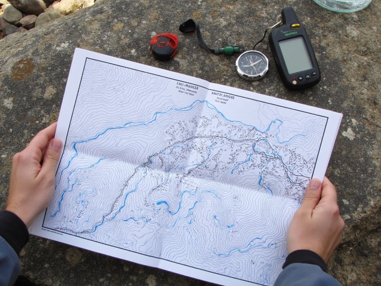
Your navigation toolkit functions as a multi-layered defense system against disorientation and route-finding failures in challenging environments. Redundancy across analog and digital systems guarantees you’ll maintain directional awareness when individual components fail.
Essential navigation components include:
- Magnetic compass – Provides reliable bearing readings without battery dependence, serving as your primary backup for compass basics orientation.
- Topographic maps – Detail elevation contours, terrain features, and scale measurements for accurate distance calculations.
- GPS devices and smartphones – Enable real-time positioning through digital navigation apps like GaiaGPS with pre-loaded offline maps.
- Documentation materials – Waterproof cases protect route notes, waypoint records, and backup paper descriptions.
Document key waypoints, elevation changes, and landmarks in written format. Orient maps using compass alignment with magnetic north. Carry portable power sources for extended digital navigation functionality.
Weather Monitoring and Environmental Risk Assessment
When environmental conditions deteriorate rapidly in remote areas, accurate weather monitoring becomes your primary defense against life-threatening exposure scenarios.
Weather technology provides essential data through automated networks like SNOTEL stations and RAWS systems, delivering temperature, precipitation, and wind measurements with satellite-supported transmission. You’ll find European models exceeding 80% accuracy compared to NOAA’s 70% forecasting reliability.
Mountain Forecast offers elevation-specific predictions vital for freezing level assessment.
Natural indicators complement technological tools effectively. Cloud formations and wind direction changes signal imminent weather shifts. Animal behavior patterns and plant responses predict precipitation without electronic devices.
Temperature drops 3-5°F per 1000 feet elevation gain, requiring route adjustments for windward slopes versus rainshadow areas. Combining weather journals with basic instruments like anemometers enhances prediction accuracy during extended backcountry travel.
Frequently Asked Questions
How Much Water Should Each Person Carry per Day in Different Climates?
You’ll need 2.7-3.7 liters daily in temperate climates, 4-6 liters in hot conditions, and maintain regular intake in cold weather. Effective hydration strategies require adjusting for climate considerations and physical activity levels.
What Backup Communication Methods Work When Satellite Devices Fail Completely?
Ham radios, CB radios, and mesh networks don’t rely on satellites. You’ll also need signal flares for visual distress signals and emergency whistles for audio alerts when electronic devices fail completely.
How Far Apart Should Team Members Stay While Hiking for Optimal Safety?
You should maintain a minimum safety distance of 6 feet between team members while hiking single file. Adjust your team spacing based on terrain difficulty, visibility conditions, and environmental hazards for ideal protection.
On a final note
You’ve got the essential framework for safe route planning. Water sources must be verified every 8-12 miles depending on terrain difficulty. Elevation gains exceeding 1,000 feet per mile require adjusted timelines and energy calculations. Emergency exits should be plotted at 25% route intervals with documented GPS coordinates. Your navigation tools need backup power systems and waterproof storage. Weather monitoring isn’t optional—it’s critical for preventing exposure incidents that compromise mission success.