Flood & Storm Preparedness: Choosing Elevated Sites and Emergency Plans
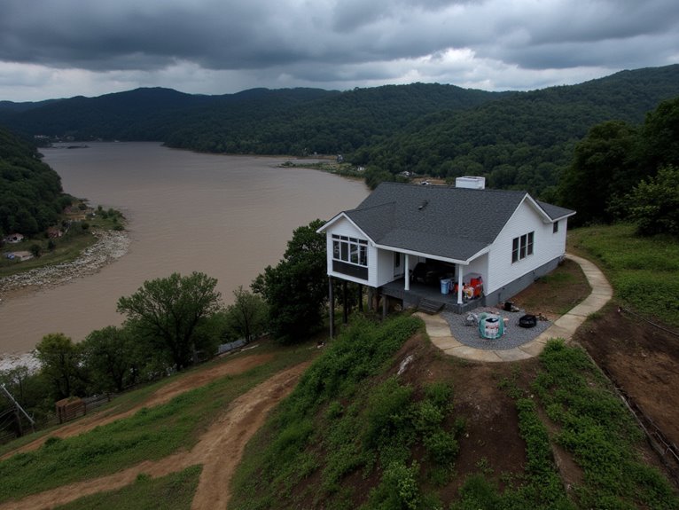
You’ll need to select sites above Base Flood Elevation (BFE) and Design Flood Elevation (DFE) using FEMA’s Flood Insurance Rate Maps and historical flood data. Check soil drainage conditions and avoid low-lying areas prone to water accumulation. Develop emergency plans with designated evacuation routes, high-ground shelters, and warning systems like NOAA Weather Radio. Consider both structural measures (elevated buildings, levees) and non-structural approaches (floodplain ordinances) for thorough protection that maximizes your safety investment.
We are supported by our audience. When you purchase through links on our site, we may earn an affiliate commission, at no extra cost for you. Learn more. Last update on 18th December 2025 / Images from Amazon Product Advertising API.
Notable Insights
- Select sites above Base Flood Elevation using FEMA flood maps and avoid low-lying areas with poor drainage.
- Research historical flood records and soil conditions to identify stable, well-draining locations for development.
- Establish Emergency Operations Centers with clear evacuation routes to designated high-ground shelters and supply caches.
- Implement community warning systems including Emergency Alert System and NOAA Weather Radio for timely alerts.
- Integrate prevention, protection, response, recovery, and mitigation functions into comprehensive emergency response planning.
Site Selection Criteria for Flood-Resistant Locations
When selecting a site for flood-resistant construction, elevation becomes your primary defense against water damage. You’ll need to conduct thorough topographic analysis to verify your site sits above the Base Flood Elevation (BFE) or Design Flood Elevation (DFE). This analysis identifies natural drainage patterns and avoids low-lying areas where water accumulates.
Elevation serves as your first line of defense—choose sites above flood elevations and away from water accumulation zones.
Research the site’s flood history through historical records and FEMA databases. Past flooding incidents reveal frequency and severity patterns that inform your decision. Check Flood Insurance Rate Maps (FIRM) to determine if you’re within designated flood zones, as each zone carries specific construction requirements. Consult local experts for additional flood risk evaluation beyond what standard mapping provides.
Evaluate soil conditions for foundation stability. You’ll want well-draining soils that support deep foundations and resist scour during flood events. Consider proximity to bodies of water such as rivers, streams, and lakes, as these represent common sources of flooding that can overflow onto adjacent lands.
Avoid areas with unstable soils prone to liquefaction or excessive saturation.
Essential Flood Risk Mapping and Analysis Resources
After identifying your ideal construction site, you’ll need extensive flood risk mapping and analysis resources to understand the complete hazard profile. FEMA’s Risk MAP program provides thorough datasets through a four-phase process: discovery, analysis, preliminary mapping, and adoption. These flood mapping tools integrate GIS software like ArcGIS with remote sensing data for accurate terrain analysis.
| Resource Type | Primary Tool | Key Application |
|---|---|---|
| GIS Software | ArcGIS | Data management and spatial visualization |
| Remote Sensing | Satellite imagery | Updated terrain and land cover data |
| Hydraulic Models | HEC-GeoHMS | Stream network delineation |
| Risk Analysis | FEMA datasets | Enhanced flood risk information |
You’ll combine soil data with land use information to create runoff curve numbers. Digital elevation models generate flow direction grids for watershed delineation and thorough risk analysis.
Building Comprehensive Emergency Response Plans
While flood risk mapping reveals potential hazard zones, you’ll need a thorough emergency response plan that transforms data into actionable procedures for protecting lives and property.
Your plan must integrate prevention, protection, response, recovery, and mitigation functions through coordinated communication structures. Establish Emergency Operations Centers for centralized command during flood events.
Include clear evacuation routes with designated high-ground shelters and accessibility provisions for disabled individuals. Effective resource allocation requires identifying emergency shelter supplies, rescue equipment, and multi-day food and water caches.
Implement community warning systems using Emergency Alert System and NOAA Weather Radio protocols. Conduct regular drills to build readiness and maintain current contact information and maps.
Your plan should seamlessly shift from development to execution, incorporating whole community involvement and private sector partnerships for enhanced capability pooling.
Structural and Non-Structural Flood Mitigation Approaches
Emergency response plans establish the framework for action, but long-term flood risk reduction requires implementing physical and regulatory measures that address vulnerability at its source.
You’ll need to evaluate both structural and non-structural approaches through thorough cost effectiveness analysis.
Structural measures include elevating new buildings at least two feet above base flood elevation, delivering benefit-cost ratios from 1.80 to 37.48. For existing structures, wet flood-proofing proves more economical than elevation, with ratios between 0.45 and 4.78. Dams, levees, and channel modifications physically redirect floodwaters.
Non-structural approaches focus on planning and regulation. Updated floodplain ordinances restrict development in flood-prone areas. Enhanced forecasting systems and emergency management protocols improve preparedness.
Risk assessment techniques help you model flood scenarios and damage estimates, requiring detailed socioeconomic data for accurate projections.
Storm Surge Vulnerability Assessment and Protection Strategies
The intensity of hurricane-driven storm surges poses unique challenges that require specialized assessment methodologies beyond traditional flood modeling.
You’ll need thorough storm surge assessment using the SLOSH model, which incorporates NOAA National Hurricane Center data to predict surge heights and flooding extents.
Your vulnerability scoring process should integrate multiple critical factors:
- Flood hazard extent and depth measurements on a 1-5 scale
- Social Vulnerability Index scores from census data analysis
- Regional drivers including infrastructure capacity and natural resources
- Population density metrics scaled for county-level risk prioritization
Modern assessment tools utilize ¼ mile hexagonal grid systems to capture granular topographic and asset data.
Digital elevation models define floodplain boundaries while visualization tools simulate current and projected surge impacts.
This multi-scale approach enhances accuracy from census block to individual building levels.
On a final note
You’ve now got the essential tools for flood and storm preparedness. Implement elevation criteria above 500-year flood levels when selecting sites. Use FEMA flood maps and local vulnerability assessments to guide your decisions. Develop multi-tiered emergency plans with clear evacuation routes and communication protocols. Combine structural defenses like flood barriers with non-structural approaches including early warning systems. Your preparation today determines your resilience tomorrow.